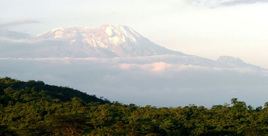
 Tanzania is home to the highest mountain in Africa – Mount Kilimanjaro (5895 metres), which is also the highest free-standing mountain in the world. Despite its height Kilimanjaro is one of the world’s most accessible high summits, with most climbers reaching the peak (Uhuru Peak) with little more than a walking stick, proper clothing and determination
Climbing Mount Kilimanjaro is a virtual climatic world tour, from the tropical rain forest on the lower slopes and alpine heath, to an almost bare alpine desert and finally the wintry Arctic summit of snow and ice, just 3 degrees south of the Equator.
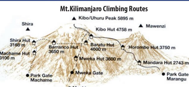
The ascent of Kilimanjaro can be done from six routes: Mweka, Umbwe, Shira, Rongai, Machame, and the Marangu Route which is the easier one. Depending on which route one wants to take, the climb of Kilimanjaro can take between four to six nights on the mountain. The two most popular routes are Marangu and Machame. On the Marangu Route, accommodation is in alpine huts while on Machame Route it is camping throughout. While expert guides and porters will accompany you on your climb, no technical equipment is required on these routes.
MT KILIMANJARO – ROUTES DESCRIPTION
MARANGU ROUTE
The Marangu or main route is by far the most popular way to the summit. The ascent is more gradual and no professional equipment is required. The accommodation on the way up and down is provided in mountain huts with all the basic necessities. There are 60 bunk beds each (for 60 people each) at Mandara Hut (2700m) and Kibo Hut (4700m), and 120 bunk beds (for 120 people) at Horombo Hut (3720m) which is also used for descent. Climbers are supplied with mattresses and pillows, but sleeping bags should be brought along. There are communal dining halls, washrooms and toilets.
It usually takes 5 days/4nights for the round trip. The trek can also be taken in 6 days/5 nights to add acclimatization with an extra day at Horombo Hut. The supplementary cost for an extra day is indicated separately as an option.
MACHAME ROUTE
This is probably the most scenic route up Kilimanjaro. The accommodation on the way up and down is strictly camping (mobile tents) only. This trek is strenuous and may be better suited to more adventurous hikers. The Machame route is normally completed in a minimum of 6 days/5nights on the mountain.
RONGAI ROUTE
There is only one route over on the north eastern side of the mountain, Rongai, which is usually a five night climb. This lesser known track may not be quite as spectacular as the western routes, but it does usually have far lower traffic than the other five night routes. This route retains a sense of unspoilt wilderness and offers a different perspective on Kilimanjaro by approaching it from the north.It is generally considered to be the easiest of the quality routes on the mountain. Rongai is the best route for people who are looking for a decent quality experience and are perhaps not absolutely confident about their fitness.
UMBWE ROUTE
The Umbwe route, which is based in the south, is a 6-day / 5-night tour and is said to be the most scenic and difficult one offered on Kilimanjaro. The first two days are extremely steep, muddy and generally strenuous making it only suitable for well-trained mountaineers. An acclimatization day is rarely offered on the standard programme, but can be added whereby giving the climber an extra day in the Karanga Valley. The descent trail is the same as the Mweka Route.
LEMOSHO(SHIRA) GLADES ROUTE
The Lemosho Glades route is perhaps the least used initial ascent route on Kilimanjaro, partly because of its remote location and likewise the difficult roads leading to the trailhead. The road to the trailhead is only accessible by 4-wheel drive vehicles and can be impassable during wet periods. The trailhead is at relatively high elevation, and thus we start slow and easy on this route. Buffalo and elephant sightings are possible on the first day trekking through the forest, and the trail is often overgrown from lack of use.
The route is the longest distance to trek up Kilimanjaro, so fitness certainly plays a role in the enjoyment and success of this trek. The Lemosho (Shira) route takes 7 days / 6 nights on the mountain. Overall, the distance covered and the intensity of the final few days make this trek a good choice only for the experienced hiker. The many changes of scenery and spectacular hike across the Shira Plateau make this trek truly special. There are no huts on this route, the accommodation is in mountain tents.
MOUNT MERU
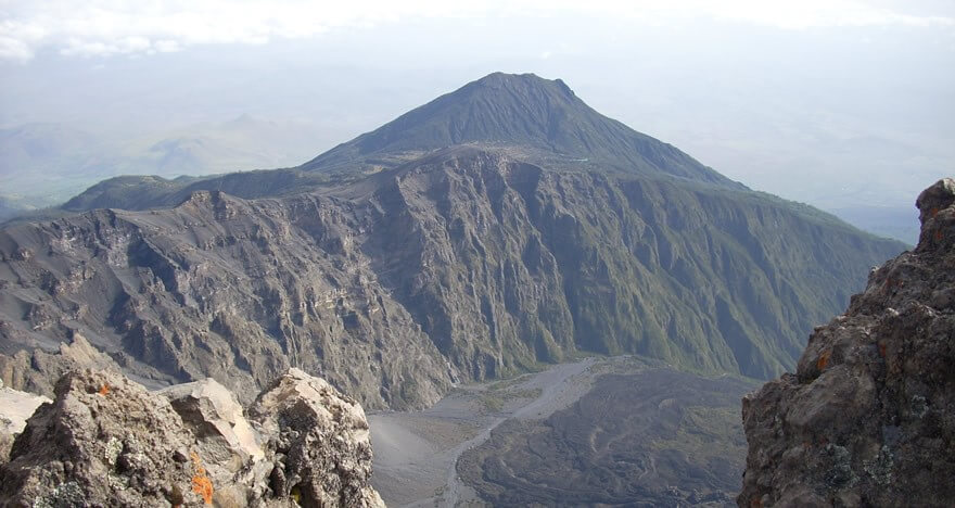 Mount Meru, which is located within the Arusha National Park, overlooking Arusha town, is the second highest mountain in Tanzania after Kilimanjaro. It is an exciting mountain to climb. There are numerous animals to see on the lower slopes and vegetation zones change as you ascend.
Parts of the climb along the saddle are very steep but the views of Kilimanjaro 80km to the northeast and of the cliff face from the summit down to Meru Crater are spectacular. One does not however need technical equipment for the climb.
Mount Meru is usually scaled in 3 days / 2 nights, but since descending from summit takes about 7 hours, some climbers opt for an extra night at Miriakamba Hut which will make it a 4-day / 3 nights climb. Overnight accommodation is in alpine huts on your way up and down.
Day 1: Morning transfer to Momela Gate (1500m) to start the climb, 3 hours walk gets you to Mariakamba Hut. Afternoon explore the Meru Crater. Overnight at Mariakamba Hut.
Day 2: Climb to Saddle Hut which will take about three hours along the steep Saddle walls. Explore Little Meru (3820m), a 1 ½ hour climb in the afternoon. Overnight at Saddle Hut
Day 3: Early morning ascend to the summit of Mount Meru (4566m) which will take up to 5 hours and then return to Mariakamba Hut for overnight OR descend to Momela Gate (7 hours).
Although Mt Meru is usually climbed from the western side at Olkokola, it can be climbed via Little Meru. The best time to climb the mountain is between October and February, although there may be some rain in November.
OL DONYO LENGAI
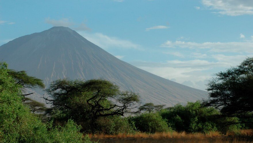 Ol Doinyo Lengai (2890 metres) is located some 240 kilometres to the northwest of Arusha town, along the western escarpment of the Great Rift Valley, overlooking Lake Natron on the border with Kenya. Ol Doinyo Lengai, or Mountain of God in Maasai, is the only active volcano in Tanzania.
The mountain can be climbed in 6 hours, affording breathtaking views of the Great Rift Valley and volcanic formations in the Ngorongoro highlands as you get to the summit. It is an adventurous hike starting at dawn. Remember this is an active volcano, the mountain remains closed for climbing when we have eruptions.
Lying on the base of the mountain, Lake Natron is said to be the only breeding area for the endangered Lesser Flamingoes that live in the Great Rift Valley and it is believed to be the world’s most important breeding site for the Lesser Flamingoes, accounting for 75 per cent of the global population.
The soda lake sits on the lowest point of the Great Rift Valley part in East Africa and is quite shallow, less than three metres deep, and varies in width depending on its water level. The temperatures in the lake mud can reach more than 40 degrees Celsius where evaporation causes high alkalinity. It is said the lake’s high alkaline environment is a barrier against predators trying to reach the flamingo nests.
The area around Lake Natron is often described as having a desolate and almost lunar landscape beauty. Walks around the lake and to the streams and waterfalls along the nearby escarpment, make for a fantastic adventure off the beaten track.
OTHER MOUNTAINS
USAMBARA MOUNTAINS
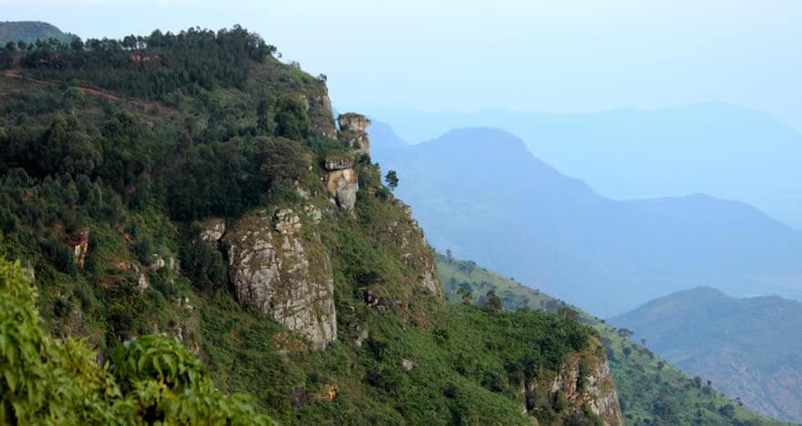 The Usambaras consist of two mountain blocks; the smaller is the East Usambaras lying closer to the coast with slightly higher rainfall. This block is less populated and its primary attraction is the Amani Nature Reserves, approached from Muheza, with its botanical garden, butterfly farming, tea & spice plantations. The West Usambaras are separated from the East by a valley and are approached via the district centre of Lushoto.
The mountains boast of over 3000 plant species in total and over 600 tree species. The Usambaras are part of the Eastern Arc Mountains which run parallel to the Tanzanian coast extending into Taita Hills in Kenya, and recognized as one of the world’s biodiversity hotspots. This exceptional diversity attracts naturalists and nature lovers from all over the world who come to watch birds, study trees and flowers or butterflies.
The Usambara Mountains, situated in the north eastern part of Tanzania, are known for their pleasant climate, beautiful view points and fertile slopes. Favoured by the Germans and English during colonial times, the area is rich in historical buildings from the period. Excursions, which take half day or less, will include hiking and visits to Wasambaa villages, where visitors may have a glimpse of daily life of the local people.
- Irente viewpoint
Hike up the Irente viewpoint to get a panoramic view of Mazinde village almost 1000 below and the vast Maasai plains beyond. On the way back, visit the Irente Farm cheese factory and the royal village of Kwembago.
- Usambara flora and fauna
Walk through the fertile farmlands of Jaegertal to a fruit tree nursery and learn about different varieties of fruit trees and their propagation. Continue uphill to the village of Vuli to see projects on soil conservation, irrigation and farming methods.
- Magamba Forest
Walk uphill from Lushoto to the royal village of Kwembago, where you learn about the cultural history of the Kilindi ruling clan. From Kwembago you have a beautiful view of Lushoto and the Maasai plains. Proceed to the Magamba rainforests, home to black and white colobus monkeys. Return via an old German Middle School, a German trench dug during the First World War and the village of Magamba.
- “Growing Rock”
The “Growing Rock” tour starts from Soni. Walk to the top of the Kwamongo mountain, famous for its butterflies, enjoy views of Soni, Lushoto and the Handeni plains from the peak. Visit the villages of Shashui and Kwemula on the way. Descend to the village of Magila at the foot of the “Growing Rock” to visit a soil conservation project and learn the mystery about the rock.
UDZUNGWA MOUNTAINS
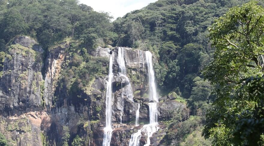 Harbouring one of East Africa’s great forests, Udzungwa Mountain National Park has an area of 1990 sq km, bordered by the Great Ruaha River to the north, with Mikumi National Park and Selous Game Reserve located further to the north and east. Protected as a national forest reserve until 1992 when it was commissioned as National Park, Udzungwa Mountains is undoubtedly one of the few true virgin and unique forested lands remaining in the world. The major attractions include its biologically diverse forest, harbouring some plant species found nowhere else in the world, from a tiny African violet to 30-metre high trees.
Apart from the forest, which acts as a water catchment area and having a large number of endemic species of both animals and plants, the park has spectacular mountains scenery, grasslands, rocks, rivers and waterfalls. One of the most interesting sights is the presence of two indigenous species of primates, the Iringa red colobus monkey and the Sanje Crested Mangabey, not known until 1979. Apart from providing habitat to about six species of primates, its plateau contains populations of elephants, buffalos, lions, leopards, African hunting dogs and several forest bird species.
Walking safaris to the Sanje River waterfalls (170 metres) is one of the popular activities in this park. Udzungwa Mountains can conveniently be combined with game drives in nearby Mikumi National Park, an hour·s drive to the north, or be included in the Ruaha National Park (4-5 hours drive) and Selous Game Reserve itineraries. The park can be visited throughout the year although it is a bit slippery during the wet rainy season. The dry season extends from June to October.